︎ Previous Next︎
Exhuming the Climate of Indonesia:
The Towuti
Drilling Project
Satrio Wicaksono ( S W )
in conversation with Anna-Sophie Springer ( A S )
& Etienne Turpin ( E T )
Published 21 June 2016
The diverse natural landscapes of central Indonesia inspired Alfred Russel Wallace to conceive of natural selection and biogeography theories, yet the region’s long-term climatic and environmental histories are virtually unknown. From May to July 2015, the Towuti Drilling Project (TDP)—the first lake drilling project anywhere in Southeast Asia—conducted an international scientific expedition to drill into the sediment underneath Lake Towuti in South Sulawesi. The obtained drill cores will be used to reconstruct the climatic and environmental evolution of central Indonesia during the past 800 millennia through biogeochemical and physical analyses. Simultaneously, this research highlights the natural processes that helped generate the landscapes Wallace saw during his own expedition between 1854 and 1862. Anna-Sophie first met Satrio, then Project Coordinator of the TDP and a Ph.D. student at Brown University, during the 12th Northeastern Conference on Indonesia at Cornell University in the fall of 2014. After an ongoing email correspondence about the unique research, and a failed visit to Lake Towuti in June 2015, we had the chance to speak about his research on the occasion of 125,660 Specimens of Natural History.
A S
Can you explain the origins of the
Towuti
Drilling Project? What began your research in this region of
Sulawesi? Why is this area important? And what is the overall aim of the
project?
S W
The Indonesian archipelago and the seas surrounding it are a major source
of global water vapor and heat, and
therefore play a crucial role in the global climate system. A better understanding
of the convection and precipitation mechanisms around the archipelago
over time will not only give us a better idea of what Indonesia’s precipitation will look like in the future but also give
us deeper insight into the past, present, and future of the global climate system.
Unfortunately, there are only limited
climate data available from Indonesia. Based on our previous research, Lake Towuti, located at the heart of the
Indonesian archipelago, contains hundreds of meters of sediment that can be used to reconstruct climatic and environmental changes during the last
circa 800,000 years, the only known such record from the region. The Towuti Drilling Project is the first scientific
continental drilling project in Southeast Asia, and from a paleoclimatic perspective, its location is just perfect.
My Ph.D. advisor at Brown, Dr. James Russell, first envisioned the
TDP about a decade ago, when he started working in the Indonesian region. As an expert on both past
tropical climates and lake ecosystems, he is interested in reconstructing and deciphering climate and environmental
information contained within layers of mud buried underneath tropical lakes. Together with Prof. Satria Bijaksana from Institut Teknologi Bandung, James
started some preliminary research at Towuti and surrounding lakes in 2007. After multiple fieldwork sessions and
analyses of preliminary data, the two of them, along with their collaborators, began writing a proposal for the drilling
project in 2012.
E T
You mentioned previously that you have done research in the region prior
to this project—can you tell us more about how you prepared?
S W
We conducted seismic expeditions in 2007, 2010, and 2013, as well as
a coring expedition in 2010. Seismic analyses
are needed to scan the sediment underneath the lake.
The “air-gun” system, which produces seismic reflection data, is akin to ultrasounds often used with pregnant
women. It allows us to detect the thickness of the mud that has accumulated on top of the lake’s bedrock
for almost one million years. Using these data, we were able to identify potential sites for coring/drilling.
The 2010 coring expedition gave us several piston cores from Lake Towuti. Each was about twelve
meters long, and their base was dated to approximately 60,000 years ago. We have done various physical, biological, and chemical analyses on these cores, and our results suggest major environmental and climatic changes
in the region during that period. These results confirmed our conviction that Lake Towuti is indeed a great site to study the climatic and environmental
changes of Indonesia. Now, with our newly recovered cores from the TDP, we hope to capture and understand
the major changes that might have occurred further back in time.
E T
In his day, all Alfred Russel Wallace needed was a letter from the Dutch
in order to collect his specimens in Nusantara;
over 150 years later, your legal requirements are much
more substantial. Also, the setup for such a drilling project is extremely
complicated. Can you give us a sense
of the logistics involved in doing this kind of research?
S W
As the TDP is an international effort, up to twenty-five foreign researchers
were involved in the actual drilling operation. We had to complete plenty of paperwork for various governmental
institutions and at different levels of government. We also brought in multiple containers and major drilling and research equipment from the U.S. and Germany. These containers and the drilling rig are
quite big, and there were only a few vehicles and cranes that could be used to transport them to our dock once
they arrived in Sulawesi. We had to coordinate with various shipping and transportation contractors to help with
the movement of our equipment. Due to technical difficulties in the middle of our project, the project had to be
extended by about two weeks, and we shipped in spare parts for our hydraulic pumps from the U.S. They were not
easy to locate and eventually arrived
safely in Sulawesi, but the journey was not without hiccups. Finally, the delay in our departure from Sulawesi caused
us some problems, as it forced us to reschedule the demobilization of our equipment and rebook our return tickets. Neither task was easy given that
our final departure date was so close to Idul Fitri, a major holiday in Indonesia.
A S
You are not the only scientist presently working at the Towuti Drilling site. Can you tell us about your team? What
scientific fields are your colleagues working in, and what they are looking for? More specifically, what it is that
you are hoping most to find?
S W
There are about thirty scientists working either at the site or the on-shore laboratory during the drilling project.
The scientists, led by Dr. Russell and Prof. Bijaksana, come from five countries and have different scientific
backgrounds. Some of us, like myself, are interested in climate questions. How has rainfall history evolved since
the lake was formed? What caused rainfall patterns to vary? What was the
environmental response to changes in climate over time? We are using
various proxy data extracted from the sediment cores to answer these
questions. A few scientists involved in TDP are
interested in the geological processes
that formed the lake. They want to determine the age of the lake, as well
as the evolution of its physical form over time. For instance, we saw a
sequence of soil, river sediment, peat, and lake sediment in some of our
drilling sites, therefore allowing us to deduce the geological evolution of
the lake, as well as how the water level might have varied over time. We
also found several thick volcanic ash layers, which might have originated
from volcanic eruptions in northern Sulawesi. If these layers can be tied to
previously identified volcanic ash layers from the region, they can be
used as time-horizon markers.
Lake Towuti also hosts many endemic species and is surrounded
by one of the most diverse rainforests on Earth. The biologists among us
are especially interested in finding microfossils from the sediment, which
may help them understand the rates of biological evolution, as well as the
sensitivity and resilience of Towuti’s aquatic and rainforest ecosystems
to climatic and environmental changes. Finally, several biogeochemists
are also involved in this project. Lake Towuti is among the world’s largest
iron-rich lakes. The ophiolite bedrock surrounding the lake supplies metals
that drive important biogeochemical processes. Drill cores allow us to
expand our understanding of these processes and closely study the impact
of climate changes on environmental chemistry. By doing so, we hope
to improve our knowledge on how to maintain a sustainable Towuti ecosystem
in light of recent changes in climate and human land-use.
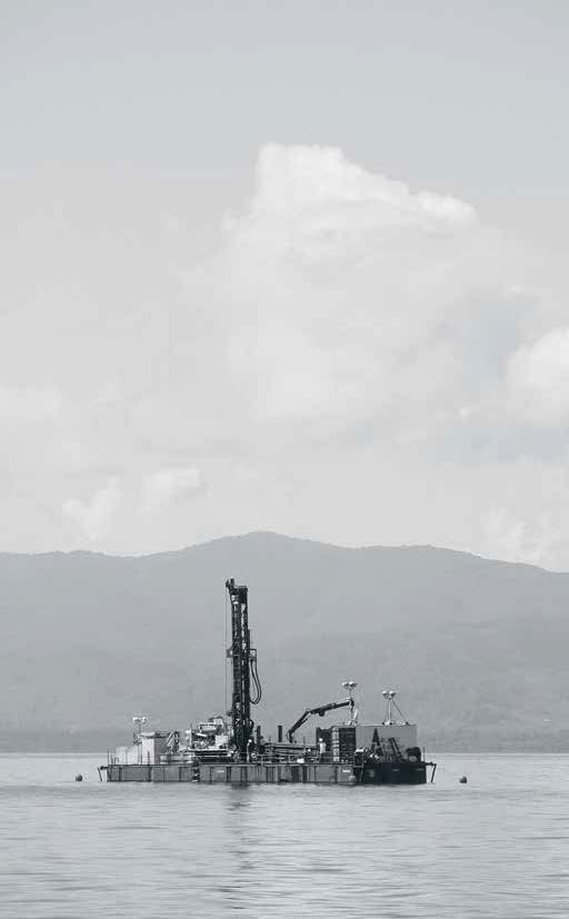
Fig. 01. Core drilling rig in Lake Towuti. Photo courtesy of the TDP.
A S
Given the size of this project, and the remote area you are working in, it must
attract a lot of attention. Are there
any concerns by area residents about
the project? What do the local communities
think about your research?
S W
We have received a lot of attention not
only from national and local media, but also from those living near the lake. The locals were particularly surprised
to see huge cranes and other heavy equipment being transported through
their villages to the project’s dock, where the gear was assembled into
a working drilling barge. The confused locals thought that this equipment
was owned by PT Vale Indonesia, a nickel-mining company operating
nearby, which has often had a contentious relationship with the locals.
Unfortunately for us, the words “drilling” and “project” also carry with them
negative connotations.
Within days after the project began, false rumors about our intentions
started to spread widely. Some people that we met thought that we were
going to do oil and gas exploration. Others were deeply concerned about
the potential environmental impacts of the project; many asked us if a
Lapindo-like mudflow disaster could happen because of our project.1 The culmination was a demonstration staged by approximately 100 local
residents and NGOs two weeks into the project. We listened to them, answered
their questions, and worked hard to explain what the TDP really is.
We were quite surprised with the moves against our scientific project,
as Dr. Russell and Prof. Bijaksana had already held a meeting with the subdistrict
head and local leaders two months prior to the start of the drilling.
In addition, the district chief had known about this project since 2012, when
it was still in the planning stage, but the information did not trickle down to
area residents. The fact that 2015 was a busy year in politics, with elections
of the district chief and village leaders looming, also added another
complex dimension.
We had already planned on doing outreach during our stay in Sulawesi,
but the miscommunication with area residents forced us to go all out
and work harder in conducting such activities. We held many meetings with
various stakeholders: local leaders, government officials, local house
of representative members, as well as representatives from NGOs. We also
visited many elementary and high schools. In addition, we facilitated visits
to our barge by government officials and locals alike, including school
children, so that they may have a better understanding about our work. By
the end, we were elated to learn that most locals had favorable views
toward our project; many of them even expressed their open support.
E T
Regarding the drilling process itself,
how long are the individual cores you are extracting from the lake bed?
What condition do you extract them in (wet/dry, hard/soft, etc.)? And what
will you do with this material next in order to study the samples collected?
S W
We hope to drill the sediment all
the way down to the top of the bedrock. Lake Towuti’s water depth
is approximately
200 meters, and the sediment underlying the water and
overlying the bedrock has a depth of about 180 meters. To perform the
drilling, we have to connect a bunch of five-meter-long drilling rods or pipes.
When the actual drilling or coring equipment is lowered down through
the inside of these rods, it brings along with it a three-meter section of plastic
core liner. The drilled core sediment is captured in the core liner, and is
prevented from falling back down by a core catcher when lifted up.
Once the liner is out on the drilling barge, scientists cut it into smaller
pieces (maximum length: 1.5 meters), put end-caps on both ends of the liners,
and label them. Visual inspection suggests that the drilled wet sediments
inside the core liners consist of different facies (for example bodies of rock
with specified characteristics representing a certain type of depositional
environment), just as we had predicted before. We are able to see claydominated
materials, sand-dominated materials, gravel-dominated layers,
peat layers, as well as tephras (volcanic
ash layers). The labeled sediment cores are
then brought to the shore during our shift change, which happens twice a
day. The cores are logged for magnetic susceptibility and other physical
characteristics using a logger that we brought from Brown University and
then temporarily stored in our field laboratory. We also sieve the sediment
left in the core catcher and analyze these tiny samples under a microscope.
The cores are currently on their way to the U.S. National Lacustrine Core
Repository in Minnesota, where the scientists involved in the project will
split them open into two halves during the core-splitting and sampling party
later this year. The working halves will be photographed and logged for
various physical characteristics using more sophisticated equipment and
finally sub-sampled to be analyzed further by different scientists in their
respective laboratories. Meanwhile, the archived cores will stay untouched
in the repository in Minnesota.
E T
In our correspondence and previous meetings, you mentioned that the core samples you collect from Lake Towuti
will provide up to 800,000 years of climate history. Can you explain more specifically how this climate knowledge
is extracted from the sample? What sciences are involved in such processes of paleoclimatology?
S W
Paleoclimatology is the study of changes in climate taken on the scale
of the entire Earth’s history. Humans started systematically collecting rainfall data from rain gauges and temperature data from thermometers only in the
past few centuries. To obtain climate data from ancient times, we can use a variety of proxy methods borrowed
from the Earth and Life Sciences that can tell us the amount of rainfall or temperature over a certain region
during a certain period in the past. The physical, biological,
and chemical characteristics of Lake Towuti’s sediment offer us clues of ancient climate history, which may
help us understand the overall pattern of climate change and assist
us in predicting how the climate might
change in the future. For example, clay mineralogy may inform us of the
types of materials that eroded easily and entered the lake, especially when the rainfall amount was high. During periods when the titanium level
in Lake Towuti was higher than usual, for instance, we may deduce that
those were relatively wet periods. Using pollens extracted from the sediment, then observed and counted under the microscope, we can learn
about the types of plants that were living in the lake’s catchment area.
Based on our pollen and leaf-wax carbon isotope analyses on the twelve-meter sediment cores from the 2010 expedition, we know that savannah was the dominant ecosystem in the area
surrounding the lake between 33,000 and 16,000 years ago, during the last
ice age. This indicates that the climate was much drier at that time. We hope
to obtain environmental and climatic information further back in time using
the longer drill cores from the TDP. One of our goals is to test whether
the climate in the region was also dry during previous ice ages, and if so, why.
CORE SCANS OF LAKE TOWUTI
by James Russell
Lake Towuti began to form about one million years ago, when movements of Asia, Australia, and the Philippines reated fractures in the Earth’s crust. Movement long these fractures allowed the region of Towuti to sink, creating the 200-meter-deep depression the lake occupies today. During its initial stages of formation, lake Towuti was much smaller than today, and oftentimes existed not as a lake but a swamp, as depicted in the formation of peat, the sediment composed by remains of grasses, trees, and other plants. This contrasts dramatically with the green, banded clay that form in the deep lake today, where the sediment is composed of fine mineral material washed in from the soils and the remains of algae and other micro-organisms that live in the lake. Indonesia has been an extremely active region geologically throughout the past million years, with frequent volcanic eruptions that spew ash into the atmosphere. Much of this ash falls onto Lake Towuti and is buried in its sediments. Although these eruptions are often very destructive, they release nutrients into the water, stimulating biological productivity by diatoms and other algae. Reproduced here are four core scans we’ve produced at our labs since the expedition in 2015. In all, we drilled ten boreholes, which are anywhere from about 40 to 180 meters long, and cores from each hole are sectioned into 0.1-to-1.5-meter-long parts. This equates to over 1,200 core sections, each of which has a separate image, so this is just a very small subset of the images we have available. When viewed together, the core scans connote large changes over immense time-scales. Sediments vary from dark to light, red to green, and each of these colors is code for large environmental perturbations. In particular, large shifts between red sediments and green sediments record large changes in the lake level, driven by wet-dry cycles in regional climate that appear linked to the Earth’s ice-age cycles. These lake-level shifts cause large changes within the lake ecosystem and surrounding landscape. Even within each individual core section, there can also be visually interesting features, including aminations that record short-term rainfall and drought cycles. Finally, if we
move beyond the macro-scale scanned images, we have microscopic images of fossil pollen, fossil diatoms, minerals, and ther materials from these cores, which tell us the composition of the sediments and can also be quite visually arresting.
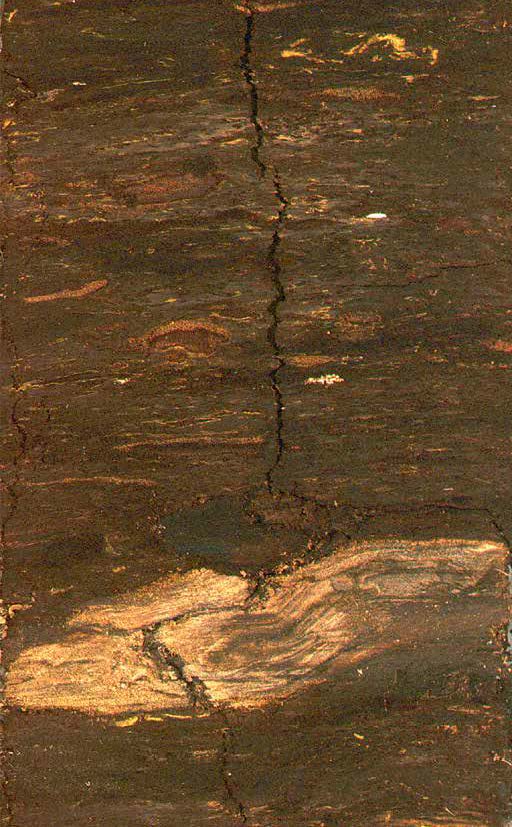
Fig. 02. Peat shows deposits from the early stages of the formation of Lake Towuti, when it was not a lake but a swamp. All scans courtesy of James Russell.
A S
In their most cited paper on the Anthropocene, British scientists Simon
Lewis and Mark Maslin emphasize the relationship between time and the Earth’s states.2 How does it feel to think
in such immense categories of time, nearly one million years into the past? Do you ever imagine the site of your research in that prehistoric state?
What might it have looked like?
Fig. 03. Diatoms represent algal blooms in the lake that form
when nutrients from volcanic ash are released into the water.
when nutrients from volcanic ash are released into the water.
S W
In the grand scheme of geological time scales, the past 800,000 years is
actually rather short. Scientists believe that the Earth was formed approximately 4.6 billion years ago. Earth
scientists like me are used to touching and observing rocks and sediment samples that are millions of years old. To us, they are not merely relics of the
past; they may also hold important scientific information about the present and the future, and as such are
immensely valuable. For example, our study allows us to understand the natural variation of the environment
and climate before humans began to populate the region.
The present-day lake must have undergone significant changes in terms of size and geochemistry due to
geological and climatic changes. Based on our preliminary data from the field we now know that lake levels have
varied. Drilling at some of our sites yielded some non-lake sections, such as river and peat units. As mentioned,
the landscapes around Towuti have not always been filled by lush rainforests. During dry and more seasonal periods, we might have seen savannah-type
ecosystems instead. You may picture a vast expanse of grasslands dotted with some trees, similar to present- day
Nusa Tenggara [Lesser Sunda Islands], during dry periods. At the same time, the lake level must have been lower,
and the lake was smaller. It was a very different picture indeed.
E T
Do you expect that the team might find evidence in these samples
for a contribution to the Anthropocene debate? According to the Geologic Time Scale, the Holocene Epoch begins in 11,650 BC, precisely the timescale
you are investigating. Is there any possibility that you could find evidence of anthropogenic ecological change
in your samples? Or, perhaps even a Global Stratotype Section & Point (GSSA) demarcation candidate
for the Anthropocene?
S W
Given the slow natural sedimentation rate in the lake (averaging 0.02 cm/year), it is a little difficult to find evidence
of anthropogenic ecological change in our samples. Archaeological and
pollen-based evidence suggest that
there was little disturbance by humans until the last century, when humans started to actively alter the landscape
around the lake. I believe that the deforestation rate around Lake Towuti has increased significantly in the last decade. Not only has logging for timber
become more intensive, but land clearance for pepper farming is also increasingly widespread. Maybe in a
few more decades the evidence of these activities will become clear in
the sediment.
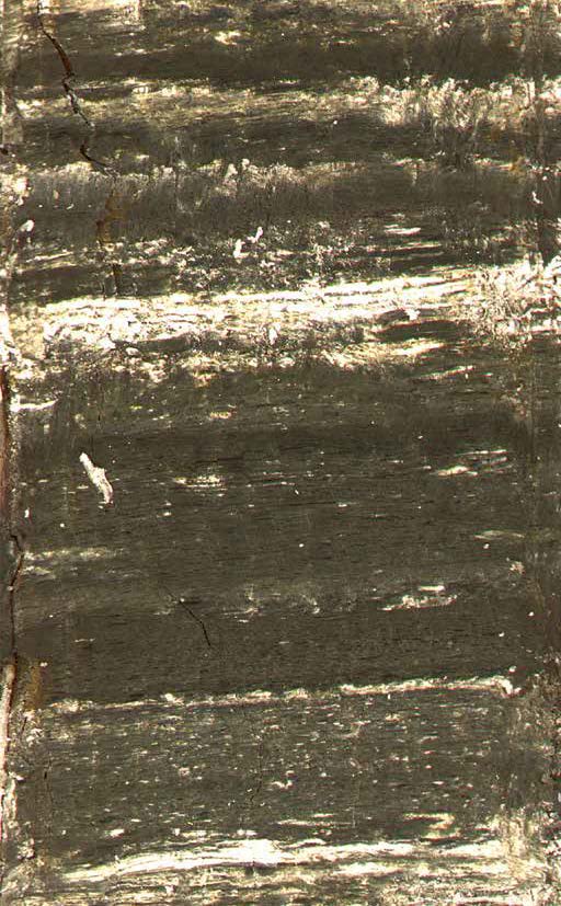
Fig. 04. Green clay shows darker-layered sediment when the lake
level is high and the climate is wet.
level is high and the climate is wet.

A S
You also mentioned the relationship of Lake Towuti and the Wallace
Line when you told us that you were
researching some specific “climate refugia” in the area. Can you tell
us about these refugia in relation to Wallace’s research on evolution, speciation, and biogeography?
It would also be interesting to learn more about
the term “climate refugium” itself.
S W
In a paper that I published recently,3
I concluded that elevation played an important role in determining the
ecological manifestation of climate change in Indonesia. Based on two
sets of climate and environmental proxy data from Lake Towuti and another
lake located at a higher elevation (Lake Matano), there was a substantial
difference in terms of rainfall and plant ecosystems surrounding the two lakes
in the past. During the last ice age, when the climate in central Indonesia
was generally drier and more seasonal, higher-elevation regions such as
Lake Matano’s catchment were wetter and had a higher percentage of
rainforest taxa compared to lower elevation regions.
Since those high-elevation regions
served as a home for rainforests amidst grassland expansion due to
the drying climate, we may call them “climate refugia.” When the climate
became more favorable (i.e. wetter), the rainforests might have expanded,
encroaching on lower-elevation regions at the expense of the grasslands.
Given that there are multiple highlands in Sulawesi, as well as other Indonesian islands, there might have been multiple “climate refugia” during
dry periods.
Our data point to several cycles of drying and wetting in the past, implying
that a series of rainforest expansion and contraction cycles might have
occurred around the refugia. The expansion of rainforests from nearby highlands
could have played an important role in the evolution of plants. Different
refugial peaks might have contained distinct plant species as they underwent
different climatic and biological
histories. Thus, when expansion occurred during wetter periods, and
different yet still-related
species intermingled, new plant species might have been produced. We thus hypothesize
that the presence of climate refugia in Sulawesi played a crucial role
in maintaining the high biodiversity
in the region.
A S
We imagine that in 800,000 years there have been quite significant changes
in Sulawesi and the ancient lake you are studying. Yet, we wonder if the more recent changes to Indonesia’s
rainforests, biodiversity, and land-use are even more extreme, but on a much shorter timescale. To change the
direction of our thought for a moment, what does the future look like given the current land-use practices in
Indonesia? In another 100,000 years, what might one find if the Towuti Drilling Project occurred again at the
same site?
S W
If you look at the landscape around Lake Towuti now, you will see patches of barren, cleared land. It isn’t difficult
to pinpoint what the culprit was. Almost every day, and peaking on the weekends, you see smoke coming from the hills bordering the lake. Farmers want
to clear the land to cultivate pepper, currently a very profitable crop, so they ignite the fires, essentially destroying
all the trees in certain parcels of land. There are also illegal loggers who fell the trees around the lake. The loggers
are slightly more environmentally friendly than the pepper farmers since they only selectively take down the
big trees. These two activities are certainly worrying, given the potential environmental impacts on the lake
ecosystem. It is also saddening given that Lake Towuti is actually a conservation area under the jurisdiction of the Ministry of Environment and Forestry.
If one were to drill the lake sediment
at the same site 100,000 years from now, one might encounter cores
that have much higher sedimentation rates during the Anthropocene than
the Holocene because of the increase in erosion. There is also a possibility
that by then Lake Towuti will be much shallower than today. Chemical fertilizers
that are used in pepper farming
may also increase the amount of
nitrates and phosphates, thus increasing the biomass of phytoplankton
and algae. As a result, sediment cores extracted in the future may have
a substantially higher percentage of organic matter than what we found
in 2015. Finally, we would see plenty of trash that humans threw in or near
the lake. Plastic bags, bottles, and other relatively non-degradable
materials
could be easily seen in future sediment
cores.
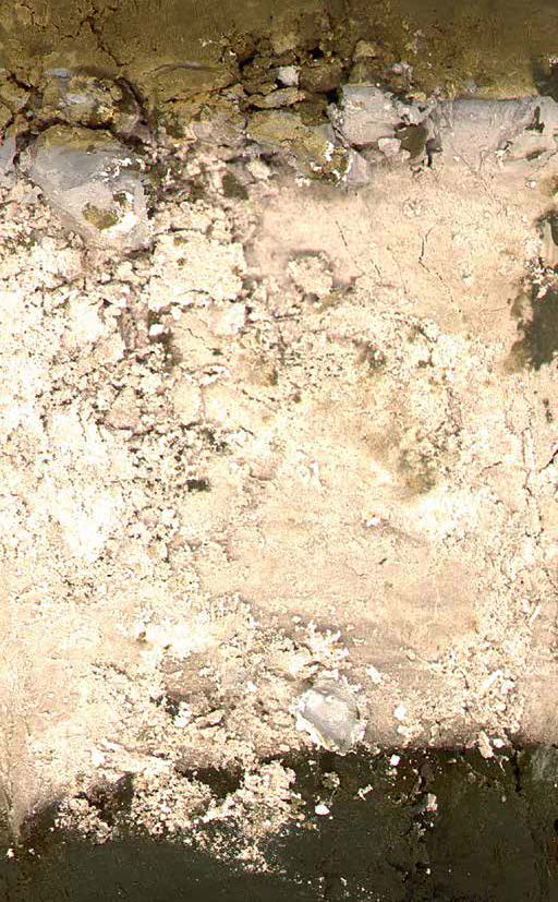
Fig. 05. Ash depicts a volcanic deposit, likely derived from North Sulawesi.
1 The Lapindo mud-flow disaster (also known as Lusi) refers to the continuous eruption of a mud volcano in Porong, Sidoarjo in East Java. This, the biggest mud volcano in the world has submerged a dozen villages, displaced some 30,000 residents, and prompted the closure and route diversion of major highways since it started erupting in May 2006. There is an ongoing controversy surrounding
its trigger. Several quarters contend that the disaster is human-made, started by the blowout of a natural gas well drilled by PT Lapindo Brantas in the area.
2 Satrio Wicaksono, James Russell, and Satria Bijaksana, “Compound-Specific Stable Isotope Records of Vegetation and Hydrologic Change in Central Sulawesi Since 53,000 yr BP,” Palaeogeography, Palaeoclimatology, Palaeoecology 430 (2015): 47–56.
3 Simon Lewis and Mark Maslin, “Defining the Anthropocene,” Nature 519, no. 12 (March 2015): 171–80.